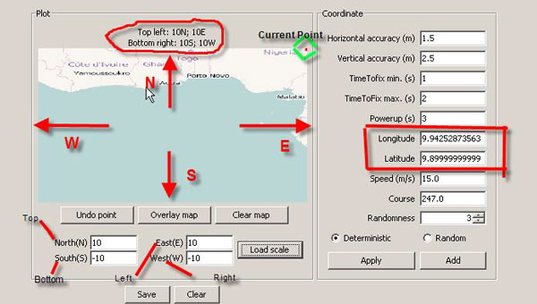
Route Generator Tool
Route Generator tool is used to load the map with North, South, East and West coordinates.
Overlay Map button allows to load the map image from the image files. Map image is scalable according the map view box.
Clear Map button allows to clear the map.
Load Scale button loads the inserted coordinates such that map view will use those coordinates as range for North, South, East and West coordinates.
North(N) = Top side of the Map: specifies the North coordinate. (refer the image for North direction)
South(S) = Bottom side of the Map: specifies the South coordinate. (refer the image for South direction)
East(E) = Left side of the Map: specifies the East coordinate. (refer the image for East direction)
West(W) = Right side of the Map: specifies the West coordinate. (refer the image for West direction)
Loaded coordinates of the map can be viewed on top of the plot panel through Load Scale button.
Coordinate for the current point on the map can be viewed as Longitude and Latitude in the Coordinate Panel.
Undo Point button undoes the current point in the map view box.
Save button creates the NMEA/SPS file for selected route.
Clear button clears all the coordinates, points and scale points for the map.
Refer the image below for more details:
